Print the Map

The current view of the map can be printed.

PREREQUISITES:

  • The print service must be added as a service resource in Designer under GISServices, and that service resource must be added to the service definition that the user is in. See Add Service to a Service Definition in the Designer Office Companion 23 Guide for more information.
  • The Spatial Reference preference must be set in Designer under PreferencesMap. See Configure Map Preferences in the Designer Office Companion 23 Guide for more information.
  • The Map Image Output Pixel Size preference must be set in Designer under Preferences > General. See Configure Map Preferences in the Designer Office Companion 23 Guide for more information.
  • The Map Image Buffer Distance for X and Y preference must be set in Designer under PreferencesGeneral. See Configure Map Preferences in the Designer Office Companion 23 Guide for more information.
  • There must be at least one map set up at the domain level.
  • You must be using ArcGIS 10.1 SP1 or higher.
  1. Click Printing on the map toolbar or select it from the Tools drop-down list.
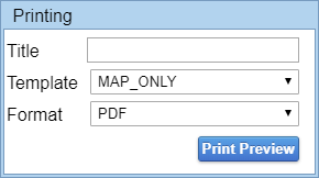
  2. Enter information in the Printing panel. See Printing Fields for more information on these fields.

  1. Click Print Preview to send the map to the Esri PrintTool service.

When the Esri PrintTool service returns the map to be printed, the map opens in a new window. In the new window, you can print or save the map image.

TIP: Your browser may consider this a pop-up and block the map from opening in a new tab. Be sure to allow pop-ups from your Cityworks site.